Mangystau is a vast territory covering more than 16 million hectares, where the Ustyurt Plateau, the Caspian Sea coastline, and the Aktau Mountains are connected by ancient caravan routes, like veins running through the body of the region.These places are often confused by name. Mangyshlak is the historical name – one found in travelers’ accounts and on ancient maps. Mangystau is the modern, official name, encompassing both the peninsula and the surrounding lands. In essence, they refer to the same place – a landscape that has learned to exist under two names at once.
Here, the Ustyurt Plateau drops abruptly into canyons and escarpments; white earth stretches to the horizon, and sparse vegetation only heightens the sense of emptiness and silence. Long ago, this land lay beneath the waters of the ancient Proto-Caspian Sea, part of the Tethys Ocean. Later, it became winter pastureland for nomadic tribes. The very name Mangystau translates as “a thousand winter camps.” Chalk and limestone cliffs, solitary rock towers, and deep depressions form a fantastical, almost lunar landscape shaped by earth, water, and wind.
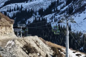
This is how Mangystau revealed itself to photographer Ernest Kurtveliev, who set off on a photographic journey across the region’s key sites – natural landmarks, ancient cemeteries, and local sacred places. “Mangystau had long drawn me in with its scenery,” Kurtveliev says. “Five years ago, I first saw photographs – especially of the western edge of the Ustyurt Plateau, a place surrounded by legends. I flew from Shymkent to the young city of Aktau on the Caspian Sea, and from there we continued inland by off-road vehicles – deep into the peninsula.”
The route led across the floor of the ancient Tethys Ocean – through Ayrakty and Bozzhyra – past canyons, the Valley of Stone Balls, sand dunes, and a camel farm, toward the region’s main shrine: the underground mosque and necropolis of Shopan-Ata.
The monuments are scattered across the peninsula, separated by vast distances. Once traveled on horseback and now by jeep, the essence of pilgrimage remains unchanged: undertaking a difficult, unhurried journey toward a sacred destination. Much of the route between sites follows well-paved roads. But once you leave the main highway and turn onto dirt tracks, venturing deep into untouched steppe, the sense of distance from civilization becomes palpable.
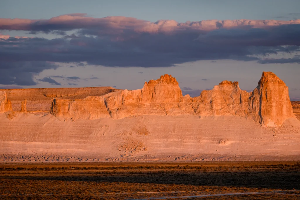
Photo: Ernest Kurtveliev
Ayrakty
“We arrived in Ayrakty closer to sunset,” Kurtveliev recalls. “It’s a cluster of rocky hills and ridges sculpted by wind, resembling towers or fortresses. Standing among these formations – in what was once the heart of the Tethys Ocean – you feel like a Lilliputian. They seem as though they were created by an extraterrestrial civilization millions of years ago. We saw numerous petroglyphs here. As dusk approaches, the place grows even more mysterious, and you begin to notice just how far the horizon stretches. The only thing disrupting the otherworldly stillness is a group of leisurely grazing camels.”
Sherkala, Torysh, and Bozzhyra
Sherkala captivates from afar, set against a glowing blue sky with drifting clouds. This legendary mountain – an isolated rock rising 307 meters high – stands some 50–60 kilometers north of the Caspian Sea coast. Its name translates as “the Lion’s Fortress.” Nearby lies one of the medieval cemeteries with gravestones of unusual geometry and intricate ornamentation, and below it stands the ancient Temir-Abdal Mosque. Judging by the well-kept graves, descendants still visit those buried here.
The Torysh tract, located about 90 kilometers northeast of Aktau, is known as the Valley of Stone Balls. Massive spherical stones scattered chaotically across the landscape give the place a distinctly mystical atmosphere. Scientists have yet to determine their precise origin; one theory suggests that the spheres formed like pearls – around a core of organic material.
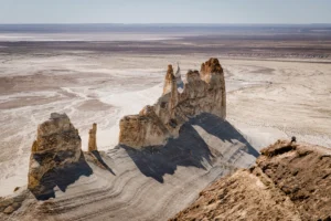
Bozzhyra lies some 300 kilometers from Aktau and is known for its chalk and limestone cliffs. Canyons, sheer drops, and bizarre rock formations rising from a white plain have made this site the calling card of Mangystau.
The road winds across the white seabed of the Mesozoic era; even the dust here is white, thanks to chalk deposits. “When we arrived, the sunset light on the ‘fang-shaped’ rock towers was mesmerizing. It’s impossible to grasp the scale of these natural castles unless there’s something human-scale nearby – like a car. We set up a tent camp and spent the night there, and I was able to photograph the starry sky. I’ve never experienced such ringing silence anywhere else. People come here for retreats and even business expeditions – they say entrepreneurs gain new insights here.”
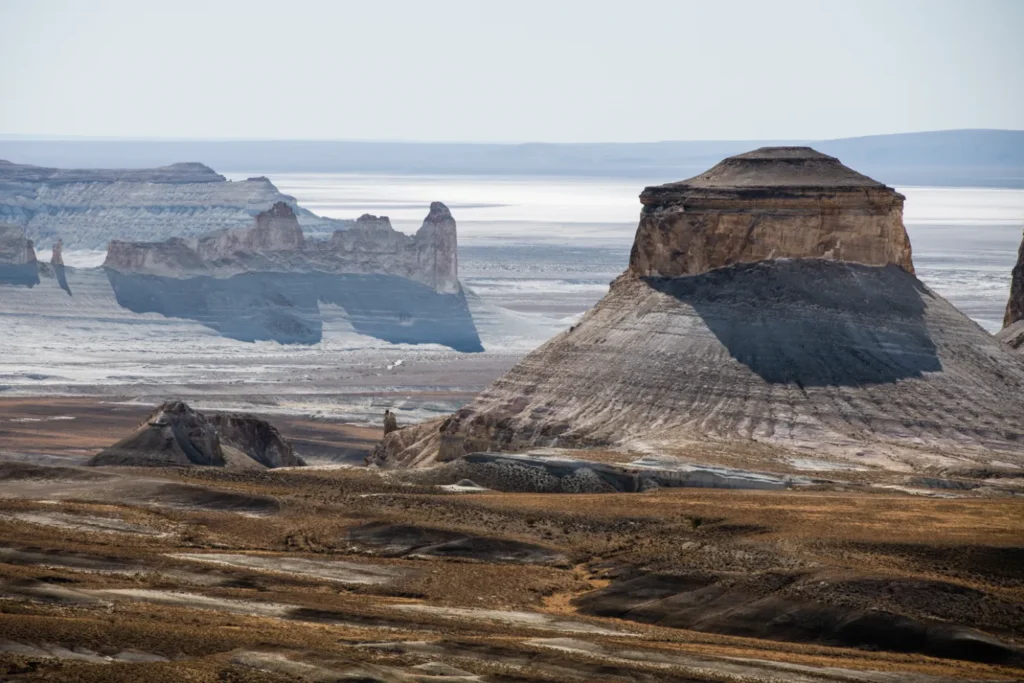
Photo: Ernest Kurtveliev
Fires are strictly prohibited in the reserve, and local guides carefully ensure order and cleanliness. You won’t see litter here. After each rainfall, traces of human presence are washed away, restoring the land to its pristine state. Due to the softness of the rock formations, the landscape will continue to evolve over the years – making a visit all the more precious now.
For centuries, Mangystau has been a land where religions replaced one another: Zoroastrianism, Tengriism, Shamanism, Judaism. It has been known as the “Land of 360 Great Sufis” since the Middle Ages, when Islam reached the eastern shores of the Caspian Sea. These figures were followers of the great medieval mystic-philosopher Khoja Ahmed Yasawi. For Muslim pilgrims, sacred sites imbued with centuries of prayer – such as Beket-Ata and Shopan-Ata – become the principal destinations of a journey through Mangystau.
Shopan-Ata
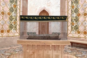
The underground mosque and necropolis of Shopan-Ata stand along an ancient caravan route from Khorezm to Mangyshlak, in today’s Karakiya district, on land once shaped by pastoral life. The life of one of the earliest preachers in the region is tied to a beautiful legend with multiple interpretations. A disciple (murid) of Khoja Ahmed Yasawi, Shopan-Ata lived in the 12th–13th centuries, served as the patron saint of shepherds, and was believed to perform miracles both in life and after death.
He is said to have traveled here for many months, following an arrow he had shot. At the spot where it landed, a mulberry tree grew. Waiting for him there was a wealthy herdsman, the elder Bayan Baba – possibly a leader of the historic Oghuz tribe – who later gave him his daughter in marriage and livestock. Burials in the necropolis date from the 10th to the 18th centuries, making it one of the largest and oldest burial grounds in Mangystau. At its center stands the mosque, founded by Shopan-Ata himself.
“At the entrance to the mosque, we were greeted by a woman in a traditional Kazakh dress,” Kurtveliev recalls. “This was Mariyam-apa, the wife of Ibrahim, the shyrakshy – the guardian of the shrine – who has served the necropolis for over 30 years. Later, I learned her remarkable story. Children were born into their family, but they died in infancy. One day, Ibrahim received a vision in a dream instructing him to serve at Shopan-Ata. At that time, the site was undeveloped. Since he became a kind of intermediary between the living and the dead, their children stopped dying.”
At the center of the cemetery is a well from which pilgrims drink water. Passing through an archway, visitors approach a stone bowl beneath the open sky – water from which birds drink. In the arid lands of Mangystau, this bowl stands as a symbol of care for all living things.
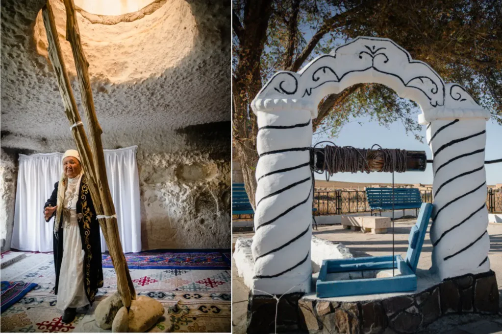
Photo: Ernest Kurtveliev
Mariyam-apa performs a special ritual, lighting tallow candles known as shyraks. Each ritual is accompanied by prayers.
Inside the mosque, the limestone vaults remain largely untouched by time. The structure’s functionality is striking: it stays cool in summer, warm in winter, and free of drafts. There are eleven chambers in the burial complex. Only men are permitted to enter the room behind the curtain where the saint’s tomb lies. A wooden pole at the entrance marks the place of burial. Sacred sites like Shopan-Ata possess a distinct spiritual presence, and the flow of pilgrims continues year-round.
“Mangystau has a deeply rooted veneration of saints,” says Zhandyra Aksenbai, a specialist in the Archaeology and Architecture Department of the Mangystau State Historical and Cultural Reserve. “According to Kazakh tradition, we are expected to visit ancestral burial grounds at least once a year. These are often located near the graves of saints – people who purified their souls of worldly concerns, guided others through doubt, and did good deeds.”
Traditionally, pilgrims visit Shopan-Ata before traveling to Beket-Ata – the grave of his disciple and successor, the spiritual patron of Mangyshlak, carved into a chalk cliff. “A sense of peace and inner calm is felt every time I come here,” Aksenbai adds. “Some pray for health, some for wealth, others for children. But it always works – something good always happens to the pilgrims. Intention is the key. Preparing for a pilgrimage is already part of it. There is no landscape in the world quite like Mangystau’s. Traveling through these largely untouched places is worth it for the breathtaking sunsets and the silence that feels almost extraterrestrial.”
The material was published in Travel+Leisure Central Asia magazine (February-March 2026)